Santa Clara, CA - Suwei and I have kind of dropped off the map in the last month or so. We were supposed to go camping up near the Sierra Buttes in August and we had planned to go to Mexico for 10 days in September, but we didn't end up doing either of those things. Instead, since late August, I've been a bit house bound with a somewhat severe case of tummy trouble.
 |
| This is your bile duct on Giardia |
Anyway, just last week, after seeing a bunch of doctors, going through a tons of tests, and eventually having a biopsy done on my bile duct, we finally figured out what it was that was causing me so much pain. I have
Giardia. I don't recommend it. It kind of sucks. Basically I have not been able to digest any fats, grains, roughage, or pretty much anything else that needs bile to break it down, for the last month. The good side of this is that I'm losing weight. The bad sides are that I'm losing weight at a very unhealthy rate. Then there is the pain, the nausea, fevers, low energy, and a bunch of other things that make each day a little less pleasant.
I figure I must have picked it up on my last backpacking trip to Yosemite early in August. It was one of Arturo's trips, which meant we were going to walk a long way and up a fair amount of elevation. I had decided to go ultra-light and wanted to try out my new
SteriPEN that Brian and Andrea got us. The
SteriPEN is proven 99.9% effective for giardia. Either something went wrong or I'm in that lucky 0.1%.
Besides picking up a case of giardia, the worse mosquitoes I've seen in years and years, and the fact that we missed the peak we were aiming for, the trip was still a heck of a lot of fun. I'll still recommend it, just don't skimp on water filtration and bug spray. Here are a few photos and details from the hike:
 Trail head:
 Chiquito Pass Trail Head - Elevation 7200 ft
Planned Destination: Merced Peak - Elevation 11,726 ft
Actual Destination: Merced Chiquito - Elevation 11,558 ft.
Distance: ~ 15 miles each way
Driving Directions: Here is a link for much better directions than I care to give (
http://climber.org/driving/chiquito.html#chiquito). Please note that we started at the Chiquito Pass trail-head instead of the Quartz Mountain trail-head. Starting a Chiquito Pass ads a couple of miles to the hike, but significantly shortens the drive.
 |
| High Water at Chiquito Lake |
Trail Description: I must say the first 7 miles or so of this trail are not all that interesting as they are mostly wooded and offer no significant views. However, it goes by quickly as the elevation gain is so slight you hardly even notice it. At mile 2 you reach Chiquito Lake and at mile 3 you realize you just walked past Chiquito Pass. Aptly named, Chiquito Pass is pretty much a non-event and you wouldn't even know it was there if there wasn't a sign just beyond it marking the southern border of Yosemite National Park.
 |
| Chiquito Pass and the Border with Yosemite National Park |
After Chiquito Pass, the trail climbed steadily, but not significantly, to the Chain Lakes Trail intersection at Mile 7 (8700 ft). The next 2 miles offered a few ups and downs and a stream crossing or two, but before we knew it, we had made it to the very pretty Moraine Meadow and another trail intersection at mile 9. We took the trail east keeping our eyes out for a use trail heading up the left side of the South Fork of the Merced River. As it was, we missed the use trail, found the river and followed that upstream. The trees were beginning to thin enough that travel off trail was not difficult. On the way back the next day, we found the use trail and saw how easily one could miss it. It's much further north of the river than we expected.
 |
| Following the South Fork of the Merced River |
Off trail we followed the Merced River up to another very pretty meadow at about 9600 ft. (mile 11.5?). The Mosquitoes were quite bad at that point, so we sprinted across the meadow and up to a rock shelf on the north side hoping to avoid them. No such luck. It was a little better, but not much. Anyway that is where we set up camp.
 |
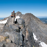
| Johannes Makes his way up a very Scenic Ridge, Merced Chiquito Peak, Yosemite National Park. |
Climbing the Peak: The next morning we set out across a frosty meadow to the granite slabs just east of the river. We followed the gully up past the point where the river petered out. We continued up a series of slabs to the left of the now dry gully until we reached a large bowl. This is where things got tricky. Up to this point we really couldn't see the Peak. As it was, what we thought was the peak actually wasn't. Honestly, we didn't know we had made this mistake until we were standing atop the wrong peak. From the bottom of the bowl Merced Peak looks like a high spot on the ridge. The point we aimed for looked very peak like, but was actually a heretofore un-named high spot on the ridge (see fig. what-the-#$Y*! below). Arturo, who is usually well stocked with GPS, maps, etc. was not happy. Although I think the spectacular view and the fact that it was still a very cool spot cheered him up a bit. We liked it so much we dubbed it, "Merced Chiquito Peak."
 |
| Arturo atop Merced Chiquito with Merced Peak Directly Behind Him. |
Unfortunately although we were only 168 feet below the actual peak, there were still a number of snow fields to cross and a tricky ridge to follow before we could reach it. After a great deal of discussion we decided against an epic and headed back down the way we came. I predict a return trip soon.
More photos:
 |
| We Camped on the Rock Shelf to the right of this Meadow. |
We Learned that Mosquitoes Love Orange / Dinner on the Shelf
Alpenglow Above the Meadow
Climbing Merced Chiquito / Johannes Navigates Part of the Ridge Between Merced Chiquito and Merced Peak.
 |
| fig. what-the-#$Y*! - Can you spot Merced Peak? Hint: It the one to the left of the photo. |
 |
| The Hike out through Moraine Meadow |
Thanks again to Arturo for organizing! We'll try again soon, maybe from a different direction. Preferably one with less Giardia.
Here is a link to the slide show:
And here is a link to Arturo's slide show:
https://picasaweb.google.com/105936391269677850066/MercedChiquito?feat=content_notification


 Trail head: Chiquito Pass Trail Head - Elevation 7200 ft


No comments:
Post a Comment