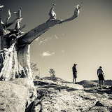
|
| This year's group from left: Karl, Rand, John, Phil, Eric, & John. |
Santa Clara, CA - John's annual Desolation Wilderness trip has become quite the tradition. I'm not sure how many years he's been hiking up there, but I was happy to be invited back for a second time. Not only is Desolation a great destination, but the trip has also become an annual Peace Corps Malawi mini reunion of sorts that I would hate to miss. Of course John, Phil and Eric were there, myself, and this year we were also joined by newbies Rand and John (A friend of Phil's and the only non Peace Corpser in the group).
 |
| The Bare Essentials |
The Saturday start required that we make another change to the plan as the Bayview campsite was fully booked by the time we got up there. Luckily John was able to call in a favor and borrow a cabin near Fallen Leaf Lake for our first night.
The next day we started out very much like we did the
year before. You may see some similarities between the two posts. I basically just used the same trail description.
The Hike In - Bayview to Upper Velma:
Trail head: Bayview Campground
Destination: Upper Velma Lake
Distance: 4.2 miles
Starting Elevation: 6800 ft.
Highest Point: Maggie's Saddle at ~8400 ft.
Ending Elevation: 8000 ft.
Heaviest Item in Pack: Either the sacks of oranges or the bottles of whiskey
 |
| The View of Emerald Bay from the Bayview Trail |
Trail Description: The two main trail heads for Upper Velma are Eagle Lakes or Bayview. We chose Bayview because it saves you a few hundred feet of climbing, and because the view from Maggie's Saddle is spectacular. From the Bayview trail head you start climbing right away through a series of switchbacks ravaged by the dreaded pine beetle (looking on the bright side, less trees mean more glimpses of Lake Tahoe). About 1 mile of this and 880 feet of elevation gain brings you to Granite Lake. After the lake the trail gets a bit steeper for another 700 feet of elevation gain, but you are soon rewarded with a great view of Eagle Lake and beyond from Maggie's Saddle.

From there the trail flattens out offering views of Mt. Tallac, Azure Lake and Snow Lake. At 2.7 miles from the trail head you reach another saddle and the intersection with the Eagle Lakes Trail. It's another 0.6 miles to the next trail intersection. Left takes you to Dick's peak & right leads to Upper Velma. From there the trail drops about 300 feet and before you know it, you are at the Upper Velma.
 |
| John Crosses the Biscut |
Our Plan: This year we followed the east side of the lake south to what we call, "the biscut" a small stream connecting Upper Upper Velma to Lower Upper Velma (look at a map and it will all make sense). We set up camp in exactly the same spot as last year atop a rocky outcrop between the two Upper Velmas. Our plan was to stay there for 3 nights and explore the area sans backpacks.
 |
| Base Camp at Upper Velma |


Day Hike #1 - Dick's Peak
Last year I had a hankering to climb Dick's Peak. At 9974 ft. Dick's Peak is the 3rd highest in the Desolation Wilderness and is easily the most interesting Peak that can be seen from Upper Velma. Last year, by the time we made it to Dick's Lake it became quite obvious that we were not going to make the peak due to the copious amounts of snow. This year however things were downright crispy in the Sierras and there was hardly a lick of snow to be found. No excuses!
We started off the same way, up the cascade at the southwest side of Upper Velma to Fontenillis Lake. Catch the Pacific Crest Trail past Dick's Lake and all the way up to Dick's Pass (9390 ft). From there you follow the ridge to an interesting scramble up to the peak. It was interesting enough that half our group decided to turn around and meet us back at camp.
From Dick's Peak we decided to continue to follow the ridge north and return to Fontenillis via the few remaining snow patches. At Fontenillis Lake we rejoined with the other half of our group and did a little rock diving at a base camp from years back.
 |
| Dick's Lake |
 |
| View from Dick's Pass |
 |
| Dick's Peak (9974 ft) |
 |
| Fontenillis Lake |
Day Hike #2 - Lower Velma and Rand's Knob
On Monday we headed downstream to Lower Velma Lake (El. 7700 ft.). There again, Phil pulls out his sneaky raft answering the question, "Who bring's a raft backpacking?". We found our highest cliff dives yet on the southwest side of the lake and proceeded to put it to good use.
Our next thought (this being quite a bit less than a plan) was to find the lake's outlet. To get there, most of us did a fair bit of bushwhacking on the south side of the lake, while John slowly drifted there by boat. Once we made it to the outlet we quickly devised an alternative plan as a horde of mosquitoes descended upon us. Seeing an interesting granite knob in the distance we decided to see if we could make it to the top. Somewhere along the way there it was dubbed Rand's Knob and the name stuck.
The views from Rand's Knob turned out to be better than expected. It overlooks Eagle lake, Lake Tahoe and has great views of Maggie's Peak.
From there we decided to follow a wide valley west of the knob back to Lower Velma. Realizing how large Lower Velma actually is, Phil ditched the group and set out for the west side by raft. The rest of us struggled with hills of manzanita bushes and large boulder fields to work our way back to our starting point. Not easy walking but still very enjoyable.
 |
| Lower Velma Lake, Desolation Wilderness, CA |
 |
| Lower Velma |
 |
| John Navigates the Outlet of Lower Velma |
 |
| Rand's Knob |
The Hike Out
The next day we hiked out the way we came in via the Bayview Trail. There is an option of heading out via Eagle Lake and Eagle Falls (which we did last year). It drops a bit more in elevation and is quite scenic, but then you have to either hike back up the road or hitch to your car. Either way is well worth it.
Once back to civilization all thoughts turned to beaches, beers, and burgers and a night at Zypher Cove where we were joined by another face from out Malawi days, Peter. He was an expat living in the north who took to hanging out with the Peace Corps folks up there.
A few more of my favorite shots from Upper Velma
Links
Here is the post from our 2011 Desolation Trip:
http://somehowlostagain.blogspot.com/2011/08/backpacking-to-upper-velma-lake-in.html
Information of Permits and Whatnot:
http://tinyurl.com/7w5na9x
Sam's Place:
http://www.samsplacetahoe.com/
Zypher Cove:
http://www.zephyrcove.com/accommodations/zephyr-cove-cabins.aspx
And here is the link to the slideshow. There are lots more photos in there, 142 to be exact: