Lafayette, CO - I finally made it through all my Buckskin Gulch photos! Granted, I took a ton of photos for 4 days of hiking. However, on top of that, I also recently upgraded to Photoshop CS4. Between trying to figure out what the heck I am doing, and playing with all the new bells and whistles, my processing speed has noticeably dropped. That said, I'm pretty happy with some of the results. Although, I'm probably still over-processing quite a bit. But enough of that, let's talk about Buckskin. Lafayette, CO - I finally made it through all my Buckskin Gulch photos! Granted, I took a ton of photos for 4 days of hiking. However, on top of that, I also recently upgraded to Photoshop CS4. Between trying to figure out what the heck I am doing, and playing with all the new bells and whistles, my processing speed has noticeably dropped. That said, I'm pretty happy with some of the results. Although, I'm probably still over-processing quite a bit. But enough of that, let's talk about Buckskin.On September 29th, 2009 a rental car full of friends pulled up to The Bean in Page, Arizona. Suwei and I were reorganizing the truck and packing for the weekend. Being well into my 4th cup of coffee, I was probably making more of a mess than actually accomplishing anything. We had just struck out two days in a row, trying to get permits to see the Wave again, so we had a day to kill before starting our hike. I tried to explain to folks, that what we were planning to see down in Buckskin Gulch, blows the doors off the Wave any day. I had hiked through Buckskin Gulch back in 2002 with Shosh, a good friend who loves the desert. Since that time I had been wanting to do the full hike through the gulch and down the Paria River all the way to Lee's ferry. Suwei probably got tired of hearing me go on and on about it, and put together this trip. As always, she did a ton of research and put together a fantastic plan. I have posted it here for anyone interested planning a trip of their own: |
Buckskin Gulch/Paria Canyon Canyoneering/Backpacking Trip, Sept 29-Oct 4, 2009
This is a trip I've wanted to do for years: Buckskin Gulch to the Paria River and then follow the river down to Lee's Ferry (near Page), AZ. Buckskin Gulch from what I read is the longest and deepest slot canyon in the United States (though in this trip we are doing only 12 of 21 miles of it). Anyways, if you haven't heard of it, just try googling Buckskin Gulch and you'll see tons of pics.
A quick note...I've read that Buckskin Gulch requires basic canyoneering skills. "Experienced hikers, those that have experience canyoneering, and rock climbers will have no problems." In particular there are 2 spots that require scrambling. I plan to bring a rope to help lower packs and aid in going down but if you are scared of heights or don't feel comfortable doing a little class 3 scrambling, this may not be the trip for you.
I currently have a permit for 6 but have checked and 5 more slots are available. Maximum group size is 10 though for a single applicant.


Quick Stats

Quick Links

Day 1: Tuesday, Sept 29


First Day in Buckskin GulchDay 3: Thursday, Oct 1


Second Day in Buckskin GulchDay 4: Friday, Oct 2


The Paria River CanyonDay 5: Saturday, Oct 3
Day 6: Sunday, Oct 4


Last Day out to Lee's FerryLogistics

We only made a few small changes to this itinerary. This is a trip I've wanted to do for years: Buckskin Gulch to the Paria River and then follow the river down to Lee's Ferry (near Page), AZ. Buckskin Gulch from what I read is the longest and deepest slot canyon in the United States (though in this trip we are doing only 12 of 21 miles of it). Anyways, if you haven't heard of it, just try googling Buckskin Gulch and you'll see tons of pics.
A quick note...I've read that Buckskin Gulch requires basic canyoneering skills. "Experienced hikers, those that have experience canyoneering, and rock climbers will have no problems." In particular there are 2 spots that require scrambling. I plan to bring a rope to help lower packs and aid in going down but if you are scared of heights or don't feel comfortable doing a little class 3 scrambling, this may not be the trip for you.
I currently have a permit for 6 but have checked and 5 more slots are available. Maximum group size is 10 though for a single applicant.
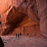
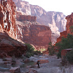
Suwei, Karl & Eng-Shien Hiking in Buckskin Gulch
Quick Stats
| Total Distance: 43 miles, not incl. some side trips sans pack |
| Number of Days: 5 |
| Average Mileage per Day: 8.6 miles |

Quick Links
- BLM: http://www.blm.gov/az/st/en/arolrsmain/paria.html
- Peter Potter's book, Classic Hikes of the World: http://tinyurl.com/l795lu
- Random websites:
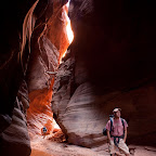
Jennifer in Buckskin Gulch
Itinerary Day 1: Tuesday, Sept 29
- Noon: Meet at Glen NRA, Lee's Ferry Ranger Station parking area.
- Take hired shuttle to Wire Pass Trailhead.
- If I can get walk-in permits for The Wave, then we'll do the 6-mile round-trip day hike out there. What is The Wave? Check it out: http://picasaweb.google.com/somehowlost/TheWaveAndOurTripHomeToColorado.
- Camp at Wire Pass Trailhead for the night.
| Start: Wire Pass Trailhead |
| Trail: Buckskin Gulch |
| End: Middle Trail Exit to the North Rim |
Distance: ~7 miles
|
| Notes: No water available on the trail for this first day. Near the confluence of the Buckskin and Paria are springs (day 2), but it is recommended that you bring a gallon of water/per day/per person; so that would be 2 gallons of water to start. |
First Day in Buckskin Gulch
| Start: Middle Trail Exit |
| Trail: Buckskin Gulch |
| End: Confluence of Buckskin Gulch & the Paria River |
Distance: 6-7 miles not incl. an optional 1.5 mile detour to Slide Arch
|
| Notes: The first possible available water source is at the camping areas, a spring 1 mile south of the confluence and another 2 miles south of the confluence. |
Second Day in Buckskin Gulch
| Start: 1-2 miles south of the confluence of Buckskin Gulch & Paria Canyon |
| Trail: Paria River End: Confluence of Wrather Canyon and Paria Canyon |
Distance: 10-11 miles
|
| Notes: The water from the spring can be filtered/treated for drinking. The water from the Paria River can also be filtered but is very silty. Probably better for jumping in and cooling off. |
The Paria River Canyon
| Start: Confluence of Wrather Canyon and Paria Canyon |
| Trail: Paria River to Highwater Trail |
| End: 1 mile down the Highwater Trail |
Distance: ~8 miles not incl. a side trip to Wrather Arch
|
| Notes: Last Springs at mile 5 for the day is the last spring water source. |
| Start: 1 mile down the Highwater Trail |
| Trail: Highwater Trail |
| End: Lee's Ferry, Glen NRA |
Distance: ~10 miles (early start as there is no shade for these last 10 miles!)
|
Last Day out to Lee's Ferry
- The closest major airport is Flagstaff, AZ. Flagstaff to Lee's Ferry, Glen NRA, is almost 3 hrs according to Google maps. The next one is Las Vegas, at 5.5 hrs.
- The Wave requires a permit. 20 permits/day, half of which are walk-in and the remainder can be obtained online beforehand. Online permits are obtained via a lottery system which needs to be entered 4 months in advance. Least to say, I didn't apply in time for the lottery. The 10 walk-in permits are available 24 hrs in advance. So I am going to try to get to the Paria Ranger Station Tuesday morning to try to get permits. I am limited to a group of 6 people.
- In either case, I would suggest flying out Monday evening after work, stay the night in whatever town you fly to, and then get up early and drive to Lee's Ferry. Trying to fly, rent a car, drive to Lee's Ferry and shuttle to Wire Pass Trailhead starting on Wednesday, might mean no Wave for you.
- If you are not interested in going to The Wave, then you can show up later. I will give you the numbers for the shuttle services and let you work out the details. Just be bright-eyed, bushy-tailed and ready to start hiking at Wire Pass by 8am Wednesday morning.
- The last day is 10 miles and I would like to get an early start: ~7am. Therefore I'm hoping to be at our cars no later than 1pm. That would give you enough time to catch a flight out that night.
- Average temperatures for the week of Sept 21-27, 2008 (from weatherunderground.com): Max - 86 F, Mean - 74 F, Low - 62 F
- Of course, we'll be checking the weather reports beforehand. If there is a chance for rain in the region, especially upstream, we will have to postpone or cancel this trip.

Our group Finishes up at the Lonely Dell Ranch near Lee's Ferry
- As I mentioned above, we were unable to get permits to see the Wave. Instead, we took a short hike to Horseshoe Bend and then spent the afternoon swimming in Lake Powell.
- On our 3rd day of hiking we overshot the last spring and ended up hiking further than we expected. We felt at the time that the published distances were a little over exaggerated. In any case we were hiking much further and faster than planned. So, on the 4th day of hiking, day 5 on the itinerary, we found it quite easy to make it all the way out to Lee's Ferry, completing the hike a day early.
Click the link below for the slide show:
 |
| Buckskin Gulch & Paria River Canyon Hike, AZ |
 |  |  |
| Eng-Shien's: Buckskin Gulch | Suwei's: 2009-09-30 CA to Buckskin Gulch & Paria Canyon | Arturo's: Buckskin Gulch and Paria Canyon |