
Sunnyvale, CA - Last Spring, we made some forward thinking plans. Plans that didn't take into account all the massive changes that were to happen over the summer. It was then that we bought our Colorado ski passes, not knowing that we'd be moving to California. It was also then that we started planning a week long backpacking trip down the west coast of Vancouver Island in Canada, not knowing that Suwei would be pregnant by that time. By mid June, we had an idea that we might need to make some changes to our plans, but we were still living in a hazy fog of denial.
Thus the idea for a backpacking trip to Lassen Volcanic National Park. The weekend of June 19th and 20th was half way through Suwei's 14th week of pregnancy and she was still feeling a little spry (albeit, mixed with bouts of nausea). She was hoping that maybe, just maybe, she would feel well enough at week 17 to take on 46 miles of Canadian wilderness. We figured this would be a good test, a 14 mile loop (7 miles each day), with a fair amount of elevation gain that could be bypassed if thing just didn't work out all that well. As it turns out, the Butte Lake, Snag Lake, Cinder Cone Loop was a perfect match.
 Butte Lake, Snag Lake, Cinder Cone Loop:
Length: 14-mile loop
Hiking time: 2 days
High point: 6,900 feet
Total elevation gain: 1,700 feet
Difficulty: moderate to strenuous
Season: late June through October
Water:available only from Snag Lake, Grassy Creek, and Butte Lake (purify first)
Directions to Trailhead: Drive Highway 44 for 11 miles east of its junction with Highway 89. Turn right at the sign for Butte Lake, go 6 miles to the Butte Lake Campground, and park in the lot by the lake’s north shore.

 We actually did the hike in the reverse direction of most of the descriptions I found. We figured that we'd start off easy and hit the Cinder Cone, the most difficult and most interesting part of the hike, at the end.
 |
| Our Group: Eric, Suwei, Karl, Erhhung, & Arturo |
 |
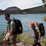
| Hiking Along Butte Lake with views of Mt. Lassen & The Cinder Cone. |
After leaving Butte Lake, we hiked 3 miles through a forest of aspens to Snag Lake. The last 2 miles of the day were spent rounding Snag Lake to our campsite on the west side. Sunday, we awoke to a damp morning and a mix of clouds and sun, but things quickly cleared up and we were off and hiking again.


Day 2 was much more interesting. We followed the west side of Snag Lake for about 2 miles before reaching the Fantastic Lava Beds at the North end of the Lake. This is where the lava flow dammed Grassy Creek and formed Snag Lake. The trail then traces the edge of the Lava Bed for another 1.5 miles. At this point you get the feeling that you are leaving the forest and entering a sort of moonscape (scorched earth). Another half mile and you are at the base of the Cinder Cone.
It's a 750 foot climb to the top of the Cinder Cone (Elevation 6900 ft.). From there you can see both Butte Lake and Snag Lake, the 2 largest lakes in the park. You can also see the extent of the Fantastic Lava Beds, and the Painted Dunes (formed by oxidized cinders). We ate lunch on the rim of the cone and just soaked in the view. The last 3 miles brought us down the north side of the cone and back to the parking lot at Butte Lake.

Snag Lake, Lassen Volcanic National Park
 | |
| Hiking along side the Fantastic Lava Beds |
 |
| Suwei climbing the Cinder Cone with the Painted Dunes behind her. |
 |
| Atop the Cinder Cone |


To summarize, it was a very nice, mellow hike, with a good variety of landscapes and some great views. That said, it proved to be just challenging enough for Suwei to make up her mind about the 46 mile epic we were planning in July. She would have to wait until she was she was slightly less pregnant.
The day was still early when we loaded our packs into the cars, so we decided to make one more stop before heading home. It was Arturo's suggestion that we check out McArthur-Burney Falls Memorial State Park, which I too will now recommend. McArthur-Burney is California's second oldest State Park (Big Basin Redwoods State Park is older by about 20 years) and is best know for the 129 foot Burney Falls. Quite impressive and well worth the stop.


McArthur-Burney Falls Memorial State Park
That's it for this entry. As always, there are a lot more photos in the slide show. Check em out here:
 |
| Backpacking in Lassen Volcanic National Park, CA |
3 comments:
If you are looking for something that can literally be a life changing experience. Having the time to pull back and enjoy nature is something that you will never forget. Backpacking is not only a hobby, but can also be a demanding sport as well.
backpacking advise
I'm hoping to backpack here with my two small children. Is there any campspots about 2 or 3 miles in alongside butte lake?
Hi Heather,
Assume you are starting from Butte Lake Campground and hiking 2 or 3 miles counterclockwise? If so, yes there are woods alongside the lake in which you can camp - there is a pic with me sitting on the "beach" along the lake with woods in the background. Hope this helps.
Also a good kids backpacking trip in Lassen is to do the 11-mile loop starting from Summit Lake to Twin Lakes to Cluster Lakes back to Summit Lake. There's 10 lakes along the way! We did this with 3 kids (ages 4, 5 and 7) across 3.5 days and it was great.
Hope this helps.
Post a Comment