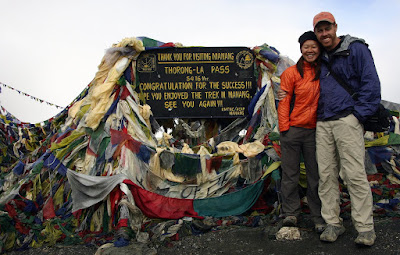
 Kathmandu Nepal - The Annapurna Circuit starts off with a 4626m (15,266ft) climb to a high point 5416m (17,873ft) at Thorang La, the circuit's first and, really, only pass. Granted it took us 13 days to make it over, but we felt pretty good about it considering our team's propensity for H.A.P.E., pre-dislocating toes, and insufficient footwear.
Annapurna is a Sanskrit name that means “Goddess of the Harvests” or “The Provider”. Located just north of Pokhara in central Nepal the Annapurna is a 55km-long massif whose highest point, Annapurna I, stands at 8,091m (26,538ft), making it the 10th-highest summit in the world. In 1950 it became the 1st peak over 8000m to be summited successfully.
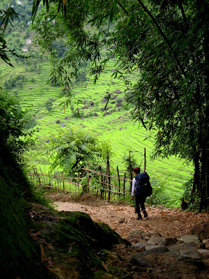
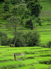
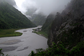
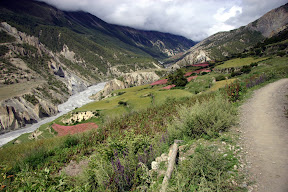
The Annapurna Circuit itself began as a series of trade routes between Nepal and Tibet. In the 1970s the Annapurnas became a popular trekking destination and now the circuit is one of the most famous treks in Nepal, and for good reason. We chose this trek, not only because it was in a book of world class treks that Suwei got from her brother, but because it looked like one of the most diverse treks in Nepal in terms of ecosystems and culture. Because of the massive elevation gain we were able to hike through jungle, rain forest, high chaparral, cloud forest, alpine regions, and desert. The culture changed from Hindi Nepalis to Buddhist Tibetans and back again. It was not a hike for wilderness, but there were sections where you were definitely out there. We thoroughly enjoyed it!
The Annapurna Circuit
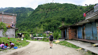
Our choice to do the circuit during the off-season was due to us being here in the off-season. (S - What Karl is trying to say is that we had NO choice on the when.) We knew we would be arriving at the tail end of the monsoon, but were hoping for a dry year. It turned out to be quite the opposite. Folks around here keep telling us that the rainy season was due to end any day now, but the rain keeps falling, land keeps sliding and all the rivers are full. That said, in the end we were glad we did it off-season. True, most of the spectacular peak views were obscured by clouds, but when they did make an appearance it seemed that much more momentous. "There's one!" Click, click, click with the camera then the clouds would move back in. Apple pie was harder to come by and the bakery shelves were empty "no meat, no bread!" What we did like, however, was that we practically had the trail to ourselves. For the first couple of days we only saw a handful of foreigners heading down the trail and it was over a week before we shared a hotel with anyone but local porters. At one empty village a hotel caretaker told us that in high season, 70 to 90 people a day would walk by (others said more), the hotel would be booked, and the floor of the dining room would be littered with bodies. We heard stories of early, early morning starts in order to get to get choice beds and in some cases, beds at all. We, on the other hand, were able to sleep in and wait for the rain to let up.
For a trip full of highlights, the Annapurna Circuit was one of our favorites. Below, Suwei has provided our HAPE inspired schedule. While I was bopping around southern Tibet she was doing research on how someone, who we now know is quite prone to HAPE, could successfully complete a trek that tops out at well over 17,000 ft. She read just about everything on the internet about the condition and spoke to the Himalayan Rescue Association regarding their recommendation. What resulted was a very relaxed, but ultimately successful plan. That said, we were nervous from the time we passed 3000 meters on the east side till the time we got back down to 3000 meters, 10 days later.
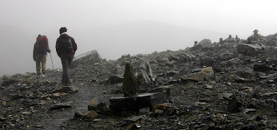
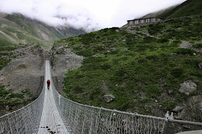
Suwei & Pram approaching Thorang La
Day-by-Day
The following are the stats of the trek, a few select pictures and a very short writeup on a per day basis.
Day 1: August 15, 2007
| Start:Kathmandu, 1300m | Distance: 190km |
| Finish: Besi Sahar, 790m | Elevation Change: -510m |
 | Took a public minibus from Kathmandu to Besi Sahar. We left just before 7am and arrived by noon in Besi Sahar even after a breakfast stop of dal bhat and several drop offs and pick ups. |
| Start:Besi Sahar,790m | Distance: 9km, @9km |
| Finish: Bhulbhule, 840m | Elevation Change: +50m |
| Start-Finish Time: 12:30-3:30pm | Total/Walk Time: 3hrs/2.5hrs |
 | This was a great beginning. Followed the road for the most part, but watched with an apprehensive jealousy as a few buses went bouncing by. No rain and lots of sun to boot. Hot and steamy! K - Things we saw: lots of porters, school kids & donkeys. |
Day 2: August 16, 2007
| Start:Bhulbhule, 840m | Distance: 13km, @22km |
| Finish: Ghermu, 1260m | Elevation Change: +420m |
| Start-Finish Time: 8am-4:30pm | Total/Walk Time: 8.5hrs/5.5hrs |
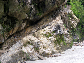
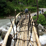
 | It rained steadily all night long and well into the next morning. Had to do a river crossing within 10 minutes of the start and the choices were either get your shoes and socks wet from the rain or the river. We choose the river and spent the rest of the day squishing up and down lush green valleys. K - Things we saw: Water running everywhere, mudslides, rockfall, school kids with umbrellas carrying their shoes so they don't get wet, massive loads on stout but stunted men, bored shop keepers, a man threatening a chicken, cows (one head-butted me in the gut) & a stubborn mule that wouldn't budge. |
Day 3: August 17, 2007
| Start:Ghermu, 1260m | Distance: 12km,@34km |
| Finish: Tal, 1700m | Elevation Change: +440m |
| Start-Finish Time: 9am-4:15pm | Total/Walk Time: 7.25hrs/6.25hrs |
 | The day started with no rain! Hurray! But toward the end of the day it started to pour and the wind picked up especially during an uphill push. Toward the end of the hill Karl attracted several leeches. The final approach into Tal was down, however, and this provided us a spectacular view of Tal. K - Things we saw: Goats trying to stay dry by hiding under a rock, more porters navigating the slippery rocks in flip flops, crazy rapids, blowing clouds, leeches, soaked villages & a damn nice pumpkin curry for dinner. |
Day 4: August 18, 2007
| Start: Tal, 1700m | Distance: 16km, @54km |
| Finish: Koto, 2600m | Elevation Change: +900m |
| Start-Finish Time: 8:15am-5:15pm | Total/Walk Time: 9hrs/8hrs |
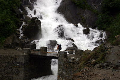
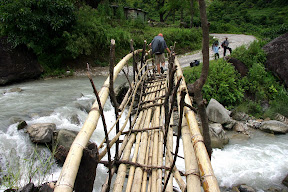
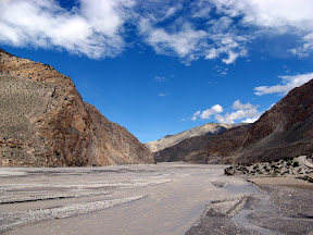
 | This was a long day with one scary river crossing (we missed the safe trail via Nadi Bazaar) and a long uphill after lunch in which this 8-year old girl carry her baby brother passed me without even breathing hard. After the climb, the trail became a wide easy road...literally...the Nepalis were trying to build a road to Manang! K - Things we saw: Kids playing in the mud, kids chasing a rescue helicopter, fog, pine trees, lumberjacks, roadwork, landslides, men playing cards, three girls trying to rock a suspension bridge, prayer wheels, and lots of waterfalls. |
Day 5: August 19, 2007
| Start: Koto, 2600m | Distance: 9km, @63km |
| Finish: Bhratang, 2850m | Elevation Change: +250m |
| Start-Finish Time: 12:15-2:15pm | Total/Walk Time: 2hrs/2hrs |
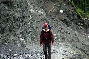 | This was the first of a series of short days. I wanted to make sure I ascended no more than 300m/day so I would have no chance of getting HAPE! Though the trail was now a wide road, there were several landslides that were slightly precarious and like quicksand (quickmud to be more exact...just sunk into a foot or more of mud). K - Things we saw: Apple porridge, a bank straight out of the old west (complete with thick, black ledger books, wood desks, wood floors, wood railings, stone walls , and a guy in a chair with a rifle across his lap leaning against the back wall), very fresh landslides, tall dark cliffs & more waterfalls. |
Day 6: August 20, 2007
| Start: Bhratang, 2850m | Distance: 11km, @74km |
| Finish: Lower Pisang, 3200m | Elevation Change: +250m |
| Start-Finish Time: 9:30am-12pm | Total/Walk Time: 2.5hrs/2.5hrs |
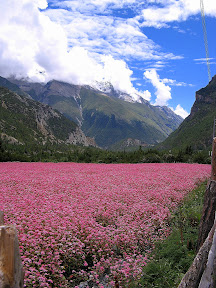
 | Hurray NO rain! Plus the scenery was going from lush tropical forest and rice paddies to sub-alpine forest and wheat fields. We actually could see tree line and smell pine in the air! Saw Pisang Peak for brief moments as clouds passed by. K - Things we saw: Forest, road crews shoving down dal bhat, the Swargadwari Danda (a huge stone bowl), rock houses, fields of flowers & the snow atop Pisang Peak. |
Day 7: August 21, 2007
| Start: Lower Pisang, 3200m | Distance: 8km, @82km |
| Finish: Humde, 3280m | Elevation Change: +80m |
| Start-Finish Time: 9:15-11:15pm | Total/Walk Time: 2hrs/2hrs |
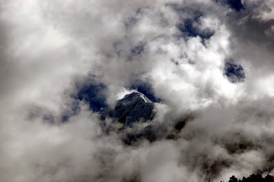
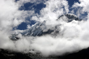
 | Though it was a lightly cloudy day we still saw lots of peaks, some snow-covered, some gray and jagged. Humde sat in a wide valley and we could see all these mountains past it in the distance. We reached Humde early and spent the afternoon sunning on the hotel deck and taking pictures of the Annapurnas. K - Things we saw: Stars, more mountains, two stoned Frenchmen drying branches of marijuana on the back of their packs, pink buckwheat flowers, an airfield that is open in high season, prayer flags & lots more Tibetans. |
Day 8: August 22, 2007
| Start: Humde, 3280m | Distance: 8km, @90km |
| Finish: Manang, 3540m | Elevation Change: +260m |
| Start-Finish Time: 9:15-11:30am | Total/Walk Time: 2.25hrs/2hrs |
 | On this stretch of the trail, the scenery was spectacular and the passing giant cumulus clouds just made everything more dramatic. At this point I was happy we had come during the monsoon season! K - Things we saw: Annapurna II, Annapurna III, Annapurna IV, monasteries or gompas high up the hillsides, glaciers, waterfalls, herds of goats, stupas with roofs, a new bridge built over an old bridge built next to an even older collapsed bridge and empty bakeries. |
Day 9: August 23, 2007
| Start: Manang, 3540m | Distance: N/A |
| Finish: Manang, 3540m | Elevation Change: N/A |
| Start-Finish Time: N/A | Total/Walk Time: N/A |
 | Rest day. This was the standard rest day that everyone and every guidebook recommended. Plus there was lots to do and see in Manang. It was a beautiful day so we hiked to the lake and then up to the glacier. K - Things we saw: Glaciers, a glacial lake, scree, Manang from high up & clouds hugging the peaks. |
Day 10: August 24, 2007
| Start: Manang, 3540m | Distance: 4km, @94km |
| Finish: Gunsang, 3900m | Elevation Change: +360m |
| Start-Finish Time: 9-10:15pm | Total/Walk Time: 1.25hrs/1.25hrs |
 | So for the rest of the ascent, Karl and I decided to hire a porter. Karl's thought was that we were going to make sure that I didn't get HAPE this far up because it was at least a couple of days to hike down to a safe elevation. The walk from Manang to Gunsang was oh-so short...we were done by 10:15am. Spent the rest of the day playing cards & napping. It was rough! K - Things we saw: Scrubby bushes, blue sheep (more like gray mountain goats, but that's what Pram, our porter, called them), a woman with more sticks than you could shake a stick at, cows wandering aimlessly, and children wandering somewhat aimlessly after the cows. |
Day 11: August 25, 2007
| Start: Ghusang, 3900m | Distance: 6km, @100km |
| Finish: Letdar, 4200m | Elevation Change: +300m |
| Start-Finish Time: 12-4pm | Total/Walk Time: 4/4hrs |
 | Started out partly sunny. We reached Letdar early which was good since it rained and became cold as the day progressed. Found a nice hotel and as the day and rain progressed, it got more and more crowded! Met a lot of other trekkers that afternoon that we keep running into even today in Kathmandu. K - Things we saw: Our breath, my Tibetan long johns, scrub, lots of locals in traditional dress heading to a festival, three German girls, a guy from Switzerland, an American, a Canadian, a Brit, and a load of Eastern Europeans. |
Day 12: August 26, 2007
| Start: Letdar, 4200m | Distance: 5km, @105km |
| Finish: Thorang Pedi, 4450m | Elevation Change: +250m |
| Start-Finish Time: 12-4pm | Total/Walk Time: 4/4hrs |
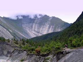
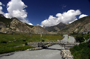
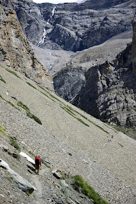 | A beautiful sunny day in which we saw peaks, rock cliffs and a waterfall. Definitely felt the altitude even without a pack! At the end close to Thorang Pedi, it was all rock, with little or no vegetation. Don't know if you can see it from this pic but a line of prayer flags runs from the top of the cliff on the left across the valley to the top of the cliff on the right. K - Things we saw: Scree, yaks, landslides, a couple from Monterey, pilgrims, and a classical guitarist. |
Day 13: August 27, 2007
| Start: Thorung Pedi, 4450m | Distance: 6km up+10km down=16km, @121km |
| Finish: Muktinath, 3760m | Elevation Change: +996m,-1656m |
| Start-Finish Time: 12-4pm | Total/Walk Time: 4/4hrs |
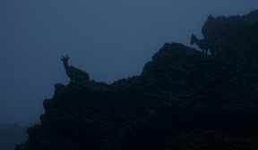 | The big day that we had been waiting for! An almost 1000m ascent and then a knee and ankle crushing descent 0f 1600m. We started early at 5am with 4 other trekkers. Just moving at a slow and steady pace...only stopping twice for nature's call...we made the pass at 5416m by 7:50am. Highest I have ever been. (In fact I climbed up a little higher to gain some privacy to use the little ladies' room...so I guess 5420m constitutes the highest I have ever been and peed.) The down was steep in many sections but the adrenaline of having made the pass was still coursing through us. K - Things we saw: Dark, fog, blue sheep, damp piles of rock, the highest point of the hike, my hand in front of my face, a scrappy yellow dog begging for food, a rainbow, an abandoned yak shelter, and a damn fine Dal Bhat. |
Day 14: August 28, 2007
| Start: Muktinath, 3760m | Distance: N/A |
| Finish: Muktinath, 3760m | Elevation Change: N/A |
| Start-Finish Time: N/A | Total/Walk Time: N/A |
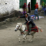
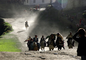 | Festival day. We had heard in Letdar of a big festival in Muktinath and lucky us...it was going to be on the day after we arrived. So we decided to join the festivities, rest our legs, and stay an extra day. K - Things we saw: Boys playing volley ball, the Yartung festival, a high lama dancing, a drunk lama falling, boys racing horses through town, pilgrims, and lots of other colorfully dressed people from all over. |
Day 15: August 29, 2007
| Start: Muktinath, 3760m | Distance: 25km, @146km |
| Finish: Marpha, 2670m | Elevation Change: -1090m |
| Start-Finish Time: 12-4pm | Total/Walk Time: 4/4hrs |
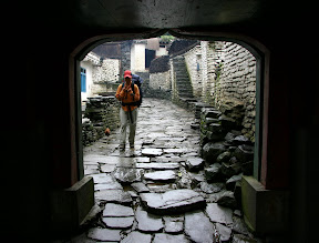
 | We were still high in elevation and the landscape was dry. Reminded Karl of Nevada. Big drop in elevation in the beginning. Leveled out after Kagbeni. But then we now understood why they call this stretch from Kagbeni to Kalapani the wind corridor. Our destination was Marpha - the most interesting town on the circuit, IMHO - walled town with cobbled streets, surrounding apple orchards, lots of Tibetan people, etc. We stayed in a really nice hotel...we were the only trekkers there...and it only cost 60 rupees (less than $1). K - Things we saw: Ruins, chillies & apricots drying in the sun, peaches for sale, kids teaching smaller kids how to urinate on a wall, a man brushing his teeth, a very old woman with thick black glasses, more pink buckwheat flowers, small ponds formed from broken irrigation ditches, heavily loaded horses/donkeys, a red tractor, motorcycles, a mountain warfare training camp, an empty ATM, a cobbler, school kids in ratty uniforms (strange as they usually looked so neat), people napping on sunny steps, large leafy trees, and temples high atop rocky cliffs. It was a long day. |
Day 16: August 30, 2007
| Start: Marpha, 2670m | Distance: 24km, @170km |
| Finish: Ghasa, 2010m | Elevation Change: -660m |
| Start-Finish Time: 12-4pm | Total/Walk Time: 4/4hrs |
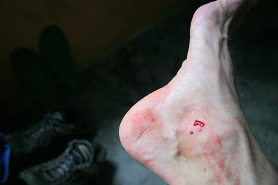
 | The day started out nice but then just started to rain off and on after 10:30am. We were truly back in wet territory again. Karl picked up a cold during this cold, wet and windy day. K - Things we saw: A flat gray river, pine trees (a few at first, then later full forests of them), rain, blisters, green fields, a town called "Dhampu" (which unfortunately seemed very apt), moldy walls, loose rocks on the trail that squirted mud, fog, waterfalls, drizzle, a woman not too happy about us dripping in her kitchen, and of course, landslides. |
Day 17: August 31, 2007
| Start: Ghasa, 2010m | Distance: 13km, 183km |
| Finish: Tatopani, 1190m | Elevation Change: -820m |
| Start-Finish Time: 12-4pm | Total/Walk Time: 4/4hrs |
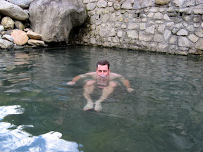 | Lots of up and downs, landslides and detours. Made it to Tatopani finally and hit the hot springs! Sweet! K - Things we saw: Massive landslides & hot springs. I was sick and mostly concentrated on getting to the hot springs. |
Day 18: September 1, 2007
| Start: Tatopani, 1190m | Distance: 17km, @200km |
| Finish: Pokhara, 820m | Elevation Change: -370m |
| Start-Finish Time: 7:30am-7:30pm | Total/Walk Time: 12hrs/5hrs |
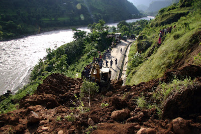 | This was an epic day. We decided to go out via Beni and pass up Poon Hill. Karl felt awful and it was cloudy in the morning so we figured there would be no view from Poon Hill. In hindsight this was the right decision...it rained steadily for the next 3 days. However, we ended up walking a lot more and taking a lot more vehicles (6 in all) than expected to finally arrive at Lakeside in Pokhara. K - Things we saw: The self proclaimed deepest valley in the world, a very unsafe safe route, a butchered animal, landslides, a 4x4 taxi, landslides, a Toyota Corolla, landslides, a bus, a washed out road, another 4x4 taxi, another massive landslide, taxi, taxi, and finally our hotel in Pokhara. |
Statistics Summary
Lowest Elevation: Besi Sahar, 790m/2607ft (the start of the trek)
Highest Elevation: Thorang La, 5416m/17,873ft (the pass)
Elevation Gain: 4626m, 15,266ft
Number of Leeches Encountered: 11 (Karl 9, Suwei 2)
Number of Times We Ate Dal Bhat: 3
Number of Times We Ate Oatmeal: A hell of a lot more than 3
Number of Vegetarian Days: 16 (everyday but the first and last days)
Number of Hot Showers: 8
Number of Cold Showers: more than 8
Cheapest/Most Expensive Lodging: Thorang Pedi @50NR/Tatopani @200NR
Suwei's/Karl's Tastiest Food on Trail: Burrito in Nehru Hotel in Marpha
Nastiest Food on the Trail: Fried noodle with slightly rancid yak cheese at The Third Eye in Kokhethanti.
Nastiest Bathroom: The Bob Marley Hotel main floor after club night, Muktinath.
Highest Either Karl or Suwei has Ever Slept: 4450 m at Thorang Phedi
Highest Either Karl or Suwei has Ever Been: 5420 m at a hill just above Thorang La
Highest Karl Has Ever Seen a Dog Lick His Balls: 5419 m also just above Thorang La (see slide show)
Highest Karl Has Ever Been: Phenom Phen, Cambodia after eating a "Happy Pizza
We took tons of photos and once again, there were so many photos that we liked that we had to break up the slide show into a four parts. Here are the links:
 |
| The Annapurna Circuit, Nepal - Part I |
 |
| The Annapurna Circuit, Nepal - Part II |
 |
| The Annapurna Circuit, Nepal - Part III |
 |
| The Annapurna Circuit, Nepal - Part IV |
1 comment:
Traveling on off season looks like so much fun. After doing the same in Burma, it seems so worthwhile to put up w/ the worse weather to avoid other tourists and have the place much more to oneself.
Love the photos as usual.
-Erik
Post a Comment